Baltic Peripeties Blog

Exploring the landscape and local legends: A historical storm surge site excursion report

Baltic Sea Region

© Paul Kirschstein

Glittering water, clear sky, soft waves and a scent that unmistakably says: You are by the sea! The Baltic Sea is showing its best face while a group of Baltic Peripeties project members sets out to explore in situ the background of an event long past on the 21st of September 2022.

Follow us along as we set out to visit the site of a historical storm surge on an excursion organized and led by Baltic Peripeties PhD candidate and historian Laura Tack, who investigates these natural events in her PhD project:

We are on Rügen, Germany´s biggest island. The southwestern corner of this landmass is made up by a peninsula called Mönchgut (“Monk´s Estate”). It is closely tied to Greifswald, where part of our project is located: This stretch of land has been among the possessions of the monks of the monastery in nearby Eldena from the 13th to the 16th century, a place made famous by the best-known son of the city, Romanticism painter Caspar David Friedrich (b. 05.09.1774), whose 250th birthday in two years is approaching fast.

Earning the view. © Paul Kirschstein

On the most southernly tip of this peninsula lies the small village of Thiessow, situated next to the picturesque green hill Lotsenberg (“Pilot´s Mountain”), and almost entirely surrounded by water – only a narrow land bridge connects it to the rest of the island. Our first stop as we ascend the hill is the view point Kleiner Königsstuhl (“Little King´s Chair”), facing south and looking out towards the island of Ruden and the mainland, only 8 and 12 km away, respectively, and clearly visible on this particular day.

At Kleiner Königsstuhl: Laura Tack introduces historical sources and folk tales concerning the storm surge at the beginning of the 13th century. © Paul Kirschstein

Looking over the water, it is not hard to imagine what we are told now: Several chronicles report how in the beginning of the 14th century – possible dates are 1304, 1307, 1309 or 1320 – a storm surge hit this part of the Baltic Sea coast and destroyed a connection to the mainland, which had allegedly existed prior to the event. The island of Ruden is supposed to be a remnant of this former land bridge, as can be seen on the map below, showing a reconstruction by Nils Petzoldt of what this could have looked like:

Reconstruction of the mainland connection and its possible shape by Nils Petzoldt. Originally published in Petzoldt, Nils. “Der Mönchgraben bei Baabe und die Landverbindung zwischen Rügen und dem Ruden,“ Pommern. Zeitschrift für Kultur und Geschichte 52.1 (2014): 4-8. Image: Kvelldulf, CC BY-SA 4.0, via Wikimedia Commons.

Not only is this flood said to have destroyed the link to the mainland, but it has supposedly also been responsible for the forging of a passageway through the shallow waters which divide the two islands nowadays: The “Neues Tief” (“New Deep”) is very narrow and was already marked by buoys by the end of the 17th century, as it was one of the few entryways into the Greifswalder Bodden (Greifswald Bay), allowing access that was vital to the Hanseatic cities of Stralsund, Greifswald and Wolgast.

Aerial view of Thiessow, the Lotsenberg and its tower to the top right. The shallowness of the water can be seen clearly from above. Image: Klugschnacker, CC BY-SA 3.0, via Wikimedia Commons.

Today, we cannot say with certainty whether the reports about the storm surge are true or not, but since the 19th century the events have been told in the context of a local folk tale, as recounted by the politician, jurist and member of the manorial court in Greifswald, Jodocus Temme (1840, 160-161):

The island of Rügen was once connected with the solid land. The present peninsula of the Mönchgut is said to have been connected with Pomerania. Some say that it was already separated from Pomerania in the oldest times, but this was only through a narrow stream, which, as some people say, was so narrow that a man could jump across in case of need. Others, however, claim that it was somewhat wider, but not deep at all, so that a bridge of horse skulls and other bones had been made through it, over which one could have gone from Pomerania to Rügen. This much is certain, that where the New Deep is now, there was before the dry land of Rügen; one can still see oaks and fir trees in some places on the bottom of the sea at low and still water.

This suddenly changed in a single night in the beginning of the fourteenth century; one cannot agree whether it was in the years 1302, or 1303, or 1308, or 1309. In one of these years, however, it is said to have occurred. There arose a terrible storm wind, which went through the whole Baltic Sea, so that it threw in the churches and houses along all of its coasts. It also tore the land of Rügen away from Pomerania at once, so that a part of Rügen sank into the sea. Two whole parishes are said to lie buried here, that of Ruden and that of Carven. Nothing remained of them but the small island, called Ruden, which lies in the middle of the Bodden.

The waterway that was created in this manner between the Ruden and the island of Rügen has since been called the New Deep. It has become a particularly good passage for the people of Stralsund. After the Gellen [passageway to Stralsund between the islands Rügen and Hiddensee – ed. Note] had been almost closed by the Dutch with their [dropped] ballast, the city would have been marred if it did not have the New Deep.

Additionally, an alternative version of the legend says that the flood arose when an ignorant woman threw a loaf of bread into the small water stream between Rügen and Ruden to cross it; this awoke God´s anger so that he called the water to make the trench wider. The wind blew for seven years from the east and after it had ended, the people retrieved the church bells of the two sunken villages from the water and put them into the churches in Middelhagen on Mönchgut and the village of Kröslin, close to Greifswald. Both church bells were from then on supposedly known for their strange sound.

True or not, these tales certainly feed our imagination about what the experience of a storm surge could have been like in this part of the Baltic Sea region and how, even after centuries, the memory still lives on in some form or another.

View over Thiessow from the Pilot´s Tower to the North: Baltic Sea on the right, Zicker Lake and Baltic Sea on the left – only a narrow connection to the rest of Rügen. © Laura Tack

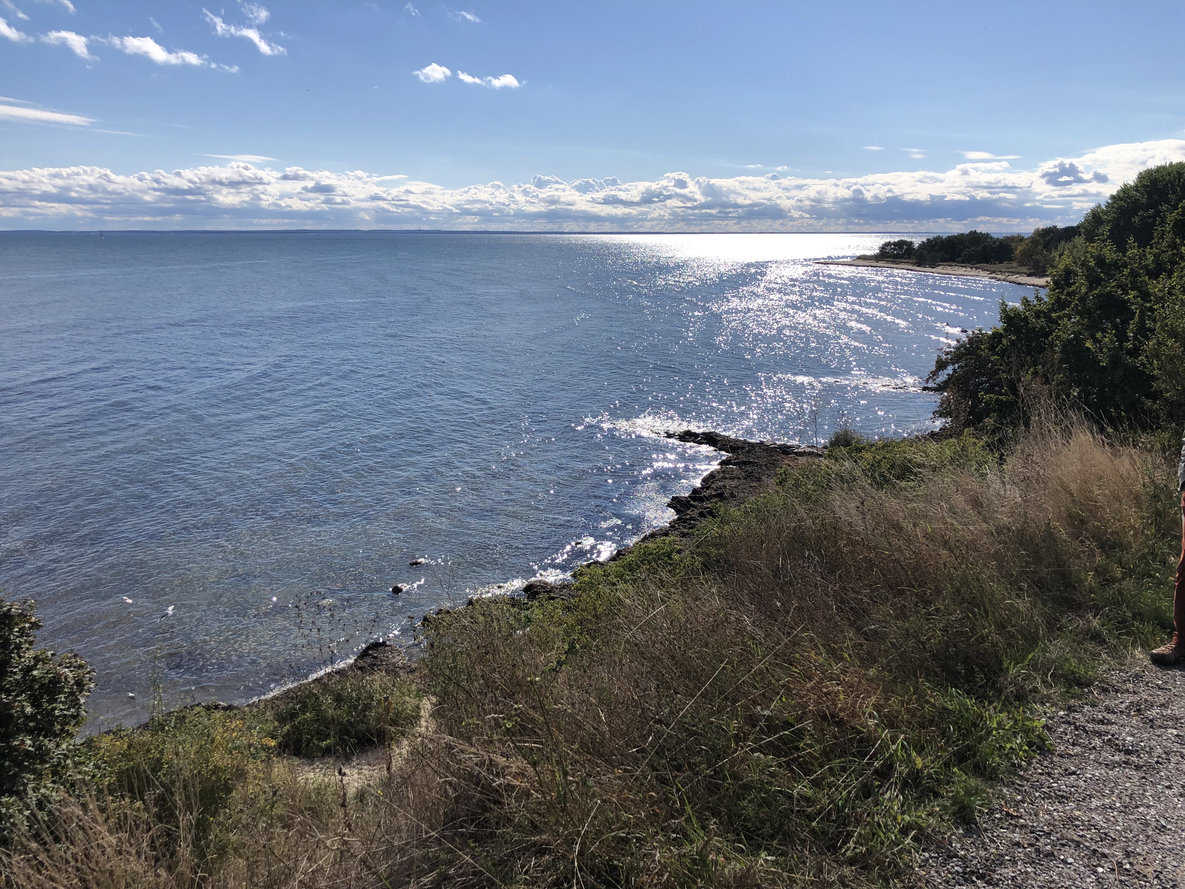
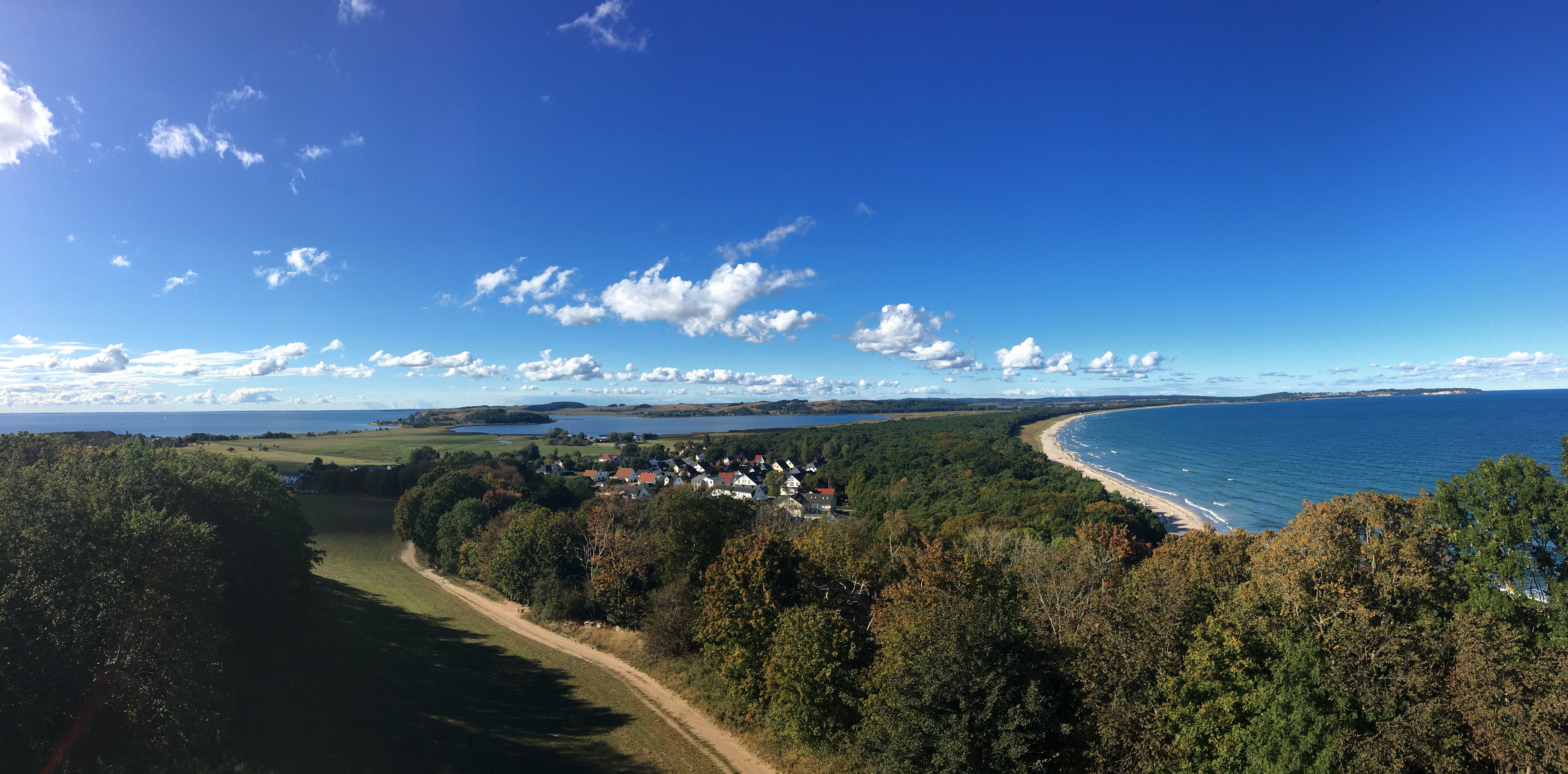
After learning about this storm surge, which is the earliest that we have several sources regarding, the tour continues to the top of the hill, where we climb the Lotsenturm (“Pilot´s Tower”). From there, we have a stunning view to the north over part of the Mönchgut Peninsula. Looking at the landscape, it is easy to see how dependent and vulnerable the communities here have been concerning the sea and its moods. Long, thin stretches of land lay next to bays reaching far inland, so that the coast is never far away.

Exactly how dangerous this can be, we learn from the account of pastor Emil Steurich in the nearby village of Groß Zicker, written in 1905 after witnessing the New Years flood in the night of the 31st of December 1904. Damaging houses and destroying boats, this flood surprised the inhabitants of the region, who quickly had to get to safety and could not believe what was happening:

“[…] everyone went to bed without worries. During the night, however, the unexpected happened: The wind suddenly shifted to the northeast and blew with hurricane-like force. The temperature, which had been mild, quickly dropped to 5 degrees below zero, and dense snow fell. Now the water rose with uncanny speed.” (Paries 1996, 211)

The fear and desperation one must feel when encountering such a catastrophic event becomes apparent through the pastor´s words:

“If at first I had been drawn to the beach by interest in the great spectacle of nature, this feeling had been completely lost and only that of horror and dejection remained. We are now defenselessly exposed to the sea and, after these destructions, are in extreme danger. How much more time will be given to our little country?!” (Paries 1996, 214)

With this in mind, we descend from the tower towards the beach, where the Baltic Sea again welcomes us, showing its most peaceful mood. It almost seemed unreal, what kinds of events we had just heard about, as we conclude our excursion with a walk where the waves meet the beach, thinking to ourselves: Indeed, how much more time will be given to this little piece of land?

Hopefully, a long while!

Baltic Peripeties excursion group on the border between sea and land. © Stephan Kessler
Further Readings
  • Kreibohm, Stephan, Karl-Uwe Heußner and Tilo Schöfbeck. Rügens Wetterchronik. Naturereignisse der letzten 1000 Jahre – ihre Ursachen und Folgen. Putbus: Rügendruck, 2020.
  • Lehmann, Henri. Rügen. Sagen und Geschichten. Schwerin: Demmler Verlag, 1990.
  • Petzoldt, Nils. “Der Mönchgraben bei Baabe und die Landverbindung zwischen Rügen und dem Ruden,” Pommern 52,1 (2014): 4-8.
  • Reinicke, Rolf. Mönchgut. Zauber einer Rügenlandschaft. Rostock: Reich, 2011.
  • Schumacher, Walter. Flutkatastrophen an der deutschen Ostseeküste. Vergangenheit, Gegenwart, Zukunft. Rostock: Redieck & Schade, 2003.
  • Steurich, Emil, printed in Paries, Georg. “Von den Sturmfluten der Ostsee,” in Rügen. Ein Lesebuch, ed. Renate Seydel. Frankfurt a.M.: Ullstein, 1996, 209-215. Translation by Laura Tack.
  • Temme, Jodocus. “Das Neue Tief,” in Die Volkssagen von Pommern und Rügen. Berlin: Nicolaische Buchhandlung, 1840, 160-161. Translation by Laura Tack.
  • Tetzlaff, Stephan. Heterotopie als Textverfahren. Erzählter Raum in Romantik und Realismus. Berlin/Boston: De Gruyter, 2016.
More on the Topic

Nothing Found